First terms: GPS is a receiver which calculates your location on the surface of the Earth. It does not talk to the satellite. I receives data from multiple satellites, like a radio, and calculates your location. To work properly, it needs a 1 inch or bigger physical dish antenna inside or connected to it. The bigger the antenna, the better the position calculation, the faster it works. Most GPS units come with a tiny GIS program to display this position against map data layers. Google Earth is a GIS program. So is every mapping program you've used to find the local Pizza Hut or WalMart. GIS and GPS go together but they are not the same, in a similar way that Gasoline and Cars go together but are not the same.
I used to work in the GIS industry and my GPS map data is current used, including the roads and hand wrapped street labels. Those were painful but necessary so they label at multiple scales of map. Cartography is not just about accurate data, but presentation for the viewer. If the labels are too small for a room level presentation read from 30+ feet away, you want bigger labels on the main roads and a big U R Here arrow pointing to the spot your speaker is discussing. I used to make those for many purposes. Even the Jehovah's Witnesses used to use my services, so they could label the "please don't bother me" folks. If you ask nicely, and firmly, they will put you on that and never trouble you again. It pays to be polite, folks. It pays dividends.
 |
| I now have something like this in the palm of my hand |
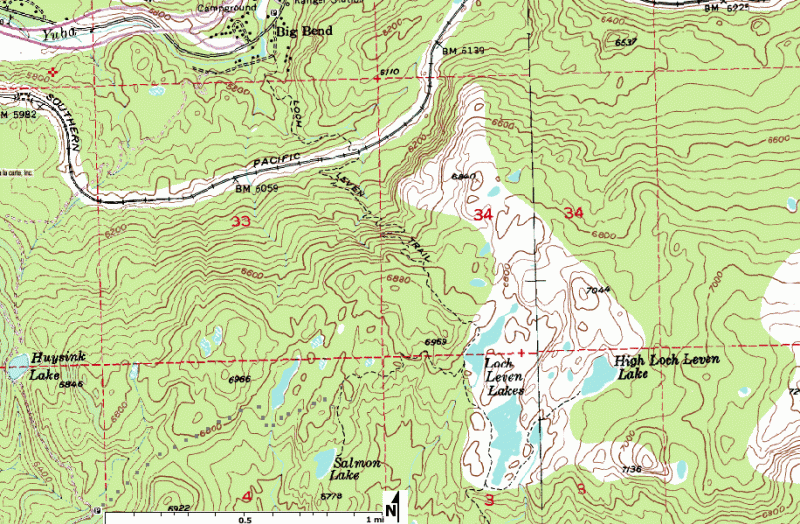
I did NOT opt to pay Garmin for their 1 : 24,000 quad map topographic data. Turns out I didn't need to either. There's tons of free data out there, with better contours, trails, etc and more free software to convert it. And the device has Gigs of storage space so even big files have plenty of room. I will eventually find aerial photos and get those in there too, which this gizmo supports. I already have water, full streets, 40 foot topos, all free. I am considering getting vegetation and possibly geology, as those suit me. I am still trying to track down high resolution trails so the next time I'm hiking I can actually see where they are rather than using my eyes to spot the blazes and footprints and disturbed brush. I'm very good at that, btw. Not just trained but experienced.
If I get this working well enough, I may loan it to my Dad so he doesn't suffer a senior moment while hiking solo and get into trouble. At his age, that is possible. Playing Sudoku will help him, but he's forgotten entire movies we watched together less than a year ago. That's... a bad sign. It's a warning. I am encouraged how he can do the math of Sudoku and his heart it good from all the exercise, almost daily at the gym. Then again, my aunt doesn't exercise at all and remains reasonably healthy if slightly confused about technology. MOST of my relatives are Luddites. Not all. I have a cousin who is a programmer, another in investment, a couple more in real estate, and one in music. These are technical jobs and require critical thinking and hard work.
Its good to get the water features in there. I will eventually get around to buying a carrying a serious portable water filter, one that can be washed and maintained, so when I'm hiking I'm not the verge of death when my water runs out. Carrying emergency food and my diabetes test kit are already standard. In the real world of hiking, you need enough water. That's your limiting factor in most cases. Its often the heaviest thing you've got, and something you can't skimp on without serious risk. Dehydration at high altitude and can get you into danger just as fast as a sudden snow storm. I take the weather seriously, I take my water and food needs seriously, and having this map gizmo is a big help.
I love that it runs on AA batteries. 18 hours of run time. That's astonishing. My old Trimble with its 7 inch antenna needed 2 or 3 camcorder batteries to work, and we carried spares. It weighed about 10 pounds, lasted about 4 hours, and we had to mount the magnetized antenna on the roof of the SUV we were using that day. It's all so much simpler now. The technology and computing power is more efficient, faster, and in GPS, its all about the FLOPS. Floating Point Calculations per Second. The better the calculation speed, the more you can make, the higher the accuracy and speed of the GPS. Multiple channels also means error checking and higher statistical accuracy. When I read complaints from Geocachers who can't find a spot and blame their GPS, I never hear them checking the satellite coverage and seeing they only have 4 in the sky overhead at the time, or asking if the soil is red and those cedar trees overhead just MIGHT have iron in them and thus make an effective radio barrier. Because that would be logical, and there's a LOT of dumb in the world.
So turns out you can get the critical software (Basecamp and MapSource) from Garmin for free, then download more software free (cGPS Mapper and MapSetToolKit) to convert public map data to work on the Garmin software and then swap back and forth into the GPS unit. So I was totally right to just buy this thing outright and not worry about the map layer data. That saved me about $200 off total cost of ownership. That's three days pay at my last job.
~~~~~~~~
Also, and this is a food thing, I found that Kraft has REAL mayo with olive oil and its cheap. Real mayo tastes better than the kind made with soybean or rapeseed (aka Canola) oil. 30 years ago, Canola oil spoiled so fast it was considered "unfit for human consumption" and then marketing made it the latest thing to avoid heart disease. Olive oil is better and keeps longer without going rancid. Coconut oil is better for frying than anything but Soybean oil and is as healthy as Olive oil. Good mayo tastes so delicious. And you can modify it with a dab of Grey Poupon Dijon mustard into one of many good sauces for sandwiches or salad dressings or fried eggs. That sauce on an egg cooked 4 minutes on low heat with a table spoon of water, then served on a toasted English muffin with a slice of cheese, ham, or both? Excellent, and very healthy. A good balance that sticks to your ribs and gives you enough energy for the day's labors. I like that.
No comments:
Post a Comment