Back when my wife still liked my company, we used to hop in our car together and pick a random road and see where it went. You would think that down on the flatland this would be really silly, but turns out those roads were interesting. When we all get hooked on freeways, we miss the interesting stuff. And there's a lot of interesting stuff near pavement. You don't even need a Ural to get there. Your basic commuter hatchback will do just fine as long as it stays paved.
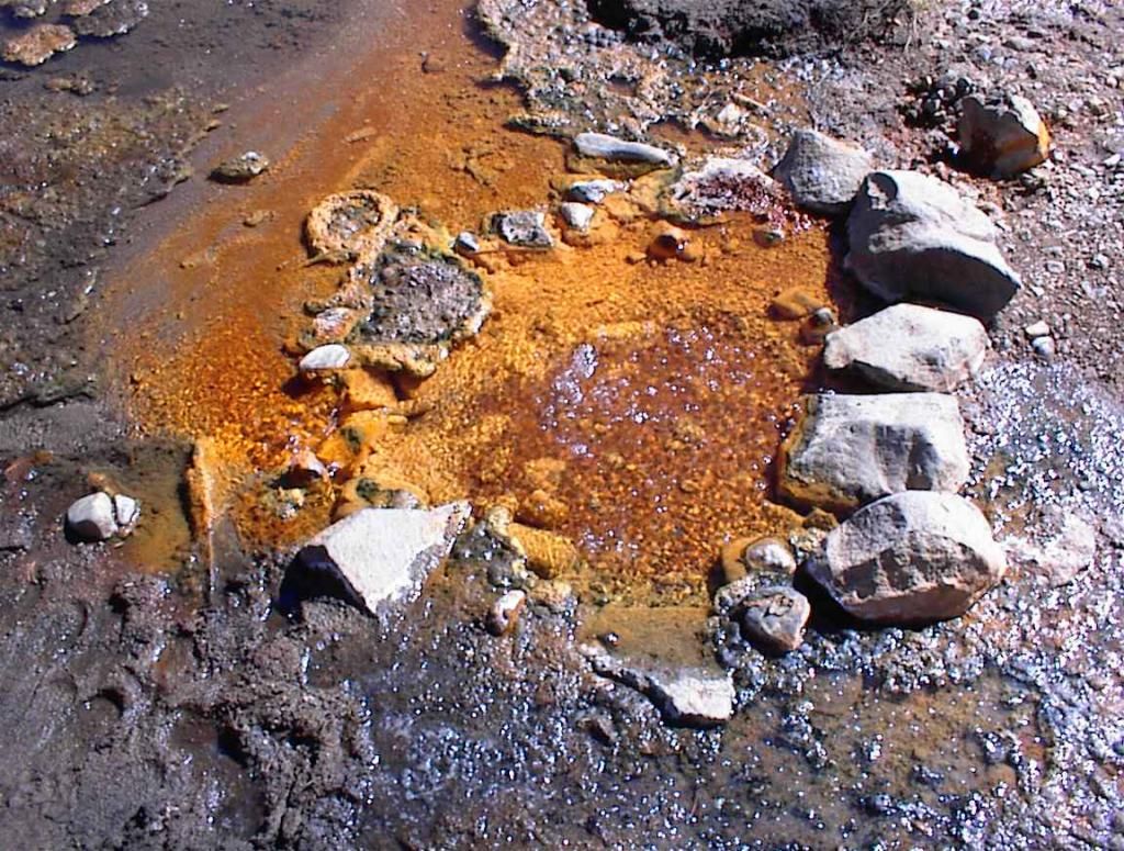
When you get into the mountains, the roads tend to go somewhere, and the pavement is more expensive to maintain so it had better be somewhere that matters, but sometimes those somewheres are ghost towns or old mines or maintained under a grandfather clause with the government so the importance has been lost. And sometimes that something is making a comeback. The gold mine at French Corral (about 10 miles as a crow flies) is reopening. Thanks to Quantitative Easing, a lot of people are buying Gold instead of government savings bonds (or Treasury Bills aka T-Bills) to hedge the value of their wealth. This is causing the price of Gold to rise, making the reopening of Gold mines a good investment. Gold mines are all over the Sierra foothills. Up and down Highway 49, a reasonably well paved road, you will see tailings and diggins and headframes and other signs of mining, still sitting there. When a mine goes bust, there is (usually) no money for environmental cleanup. So you get these piles of mine tailings and rusting stuff against a backdrop of big vistas. It's great for photography, especially folks like me who aren't that good at it. So bring your camera. Something with zoom and possibly filters for UV and a tripod. Also bring water and a tire repair kit and an air pump, just in case you get a flat. Some of these places are rural enough you might not have cellphone reception, or the cost of a rescue could end up rather pricey. So carry the essentials to get back to civilization again.
I always explore with sufficient critical supplies so if I get stuck, I won't just up and die there. It's also a good rule when traveling in the Sierras to carry winter weather gear. We have had snow on the 4th of July, and not small amounts of it. I'm talking blizzards. The Sierras are the poster child for severe weather. Most of those stories about being trapped in an unexpected blizzard originate from here. It makes them savage and beautiful mountains, and you end up loving them that much more for their dangers. Naturally, the parks in California are one of the big reasons to come here. You take your kids to see Yosemite and try to maintain your blase sense of cool while the Valley walls, a couple thousand feet over your head, lean over you. Don't bother. Gape like everyone else. It's allowed. It's practically mandatory.
I think, if I'd had kids of my own, I'd take them exploring like my Dad took me and my brother out and about. There's so many interesting places to see, and it helps you comprehend the scale of the world, even from this tiny corner of it, that your horizons are not so limited to the Bay Area, for example, or the Island of Manhattan. It's a big world. Much of it can be safely explored, again and again. I find the best way to explore is go very slowly so you can really take it all in. And go offseason so that's not getting you in someone's way. This is another good reason for bicycle tourism, scooters, and motorcycles. You naturally tend to go slower on those, so you see more. If only motorcycles didn't unconsciously steer wherever you're looking, so looking off to the side steers you off to the side. That can be bad.
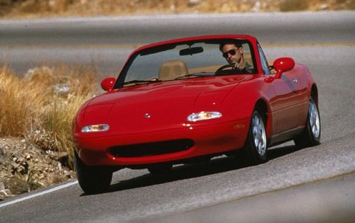 |
| Mazda Miata, 1993. |
For those who'd rather avoid the pitfalls of two wheels on unfamiliar roads, I suggest the Mazda Miata convertible for paved roads. They're like the English roadster convertible, except they always start so they don't strand you on the boonies. There's a point where discomfort becomes ridiculous and that's a defining characteristic of classic English cars: bad electrics makes them unreliable. And ragtops are unfun above 55 mph. Stick to the secondary roads without stoplights and you'll have a better trip than super-slab (freeway) offers. The right hat and possibly goggles to cut down on wind drying out your eyes is probably a good idea too. They currently make them in several styles, including the old fashioned ones and newer ones which will fit over glasses if you wear them. If you're going to risk gravel or unpaved roads then give serious thought to carrying a winch, shovel, and a hand saw with you, just in case your 4WD/AWD gets stuck.
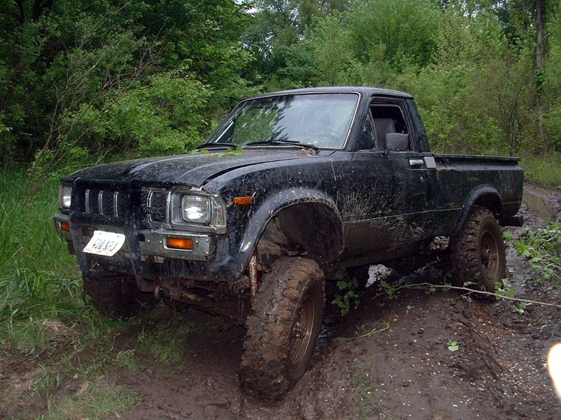 | |
| Even THIS can get stuck. |
That said I've found some great paved roads in California you might not have been on yet. First, there's Highway 49. It runs on the west side of the foothills from down near Fresno all the way up to Downieville, where it finally climbs the Sierras and goes over the pass down to meet up with highway 85 near Sierraville. This is an important place because the meadows there are one the East side of the Sierras but drain WEST through them thanks to the Mohawk Fault, which marks the northern end of the Sierras and the Southern end of the Cascades. The river and the fault are both OLDER than the Sierras. The mountains came later. I really wish my Geology teachers had spent some time on that subject because its important and geologists get asked about it all the time. We should not ignore important things just because they are close by. It is one of my primary disagreements with my professors over my education. Highway 49 is twisty and full of history and there are mines every few miles, though you have to pay attention to see them. Highway 49 is named for the year that the Gold Rush got underway, though it took most of a year for the discovery of Gold in California to reach the East coast and get them headed here in droves. Droves are like herds of cattle, btw. Drover used to be a job title. The 49ers are all the fools who came to California to strike it rich. Most died of exposure, some unlucky souls died from drug overdoses or food poisoning. It was very popular to sell "patent medicines" containing opium to the miners for gold nuggets or powder. Most of the really cool bird species and wild game like Tule Elk were killed to feed the miners. They're still trying to recover, even now.
Another good road is highway 89. 89 runs down the East side of the Sierra, up the West shore of Lake Tahoe all the way to highway 70 at Grayeagle, then splits off from 70 in the Feather River Canyon heading north to Shasta. It's twisty and high elevation and covers some of the prettiest territory in the Eastern Sierra. It is worth driving on, and not just the part that runs on the West shore of Lake Tahoe. Continue North past Truckee and its fantastic high Sierra wilderness, the northern branch of the Little Truckee River, old historic barns, and some good fishing too. Most of the side roads off of 89 are genuinely interesting, but they're best seen in October when the aspens turn golden. This is where your digital camera will thank you for lens filters and a tripod because you want those colors bright and beautiful. Shoot in RAW format, not JPEG. You'll thank me later.
Highway 70 is one of those nifty secret roads all the locals know but you don't. Highway 70 follows the Feather River from Sacramento, where it starts, to Highway 395 on the Nevada border. The Feather River Canyon is one of those driver roads that are whispered about by people with really good sports cars, Porsches and Audis, cars that handle well. Anywhere you stop on the way is likely to have trout, because its a primary trout fishing river in California. Its also the lowest pass through the Sierras so is often open when others are closed. It is heavily dammed and the power generated is used to pump water to Los Angeles, who owns the rights to a huge amount of the water and all the electricity generated. The railroad routes through there, as an alternate to Donner Pass, its high point being in Portola which has a nice railroad museum but used to be a very active repair yard, like Roseville. It is a fantastic road to drive if you have a convertible in the summer or a sunroof at least. The canyon is narrow and twisting so its challenging to corner it properly and the many bridges and dams make it that much more interesting. There are tunnels through the granite. At the bottom of the canyon is a Highway Patrol speed trap and a big lake called Oroville, which is the second largest in the state and supplies water for the Central Valley agriculture. At the top of the canyon there are alpine meadows that reach for miles and a town that looks so gingerbread you'd swear it was fake. A pity its been hit hard by poverty, thanks to Northern Pike (fish) in Lake Davis impacting the fishing tourism. If the Pike escape, they will kill everything downstream. They're vicious, like piranha, and invasive. Its a real environmental disaster.
Highway 70 makes a nice loop to highway 89, which you can follow through Lake Tahoe, then spend the night or drive on down highway 88 instead of 50, though 50 has its pretty parts too, and some nice hiking opportunities at Horsetail Falls in Desolation Wilderness. The downside to 50 is it turns into a boring commuter highway once you hit Placerville. I would say it is too wide and convenient to be fun.
I'm just including the Sierra highways here. There are lots of nifty side roads too. The Gold Lakes road that runs from 49 to 85 is fantastic, mainly because Sardine Lake and Gold Lake are both scenic and good trout fishing at the northernmost extent of the Sierras. It is glacially carved and very pretty, and the lakes are mostly cirque lakes with alpine meadows. They're rarely crowded and very pretty to visit for a picnic. Take your camera, for sure. From Highway 70 there's a turnoff north where 89 continues towards Shasta and Lake Almanor which reaches North of the mountains and offers some interesting alpine meadows without all the crowds, very remote, very rural, mostly cattle and a few cabins. Fantastic and interesting places but probably cold as a freezer in wintertime.
Off of Hwy 89 just north of Truckee and I-80 there are a series of lakes and reservoirs (man-made lakes) with barely maintained forest service roads connecting them. People live out there too. Its basically high desert conditions: sagebrush, bunch grass, pine trees, and they get snow. If you have a rally car or 4WD, this is the place for you. Its also good for mountain biking and off-road or Enduro motorcycles. Interesting roads to drive on, curious sights to see, and good fishing, all within short distance of help when you break your axle or rip open your transfer case on that rock you though you could clear but didn't quite after all. You know, THAT rock. It looks so much smaller when you get out and stare at the thing that wrecked your off-roading vehicle. Isn't that something? Later, after the tow truck comes, you can have a nice sandwich or BBQ in Truckee, which has found itself with higher end clientele than they used to so they serve better food now. Its only 90 minutes east of Sacramento, after all, and another 70 minutes to Reno, give or take. That's not that long for good fresh fish when trucks are passing every few minutes anyway, and the main line for the East-West of Southern Pacific is going through town. There are upsides to being on the transportation route. Even if every third truck says Walmart on the side. There's a major warehouse for them in Reno.
For Eastern Sierra views of essential mind blowing purity, there is Highway 395. Start in Reno and head South. It just gets prettier and prettier as you go South till you have lost enough elevation to reach the desert. The initial climb up to Carson City is dull and boring as you pass between the Silver mountains and Mount Rose. After that, it becomes amazing because there's enormous alpine meadows in Minden, then you curve down the Walker River gorge to Bridgeport, which is another alpine meadow. I'm big on Alpine Meadows because they are very special and somewhat rare.
On the way, be sure to take the June Lake Loop. June Lake was carved by glaciers and looks it. Its one of those secret places which has been developed in a good way, not offensively. You can camp or stay in a motel or a fancy hotel cabin, depending on your wealth. The food can be good or bad, depending. In the winter they have a ski resort. In the summer, they have really good trout fishing and better hiking up the sides of the U-shaped valley and up towards the glacier hidden in the shadow of the peaks. Its got great views, all the way up, but its high elevation so be in good shape, and mornings are COLD. Bring sunscreen and long sleeves.
 | |
| June Lake, 1998. One of my favorite pictures ever. By Me. |
Further south on 395, stop at Kehoe Hot Springs Road South of Bishop. The water in the creek under the high tension power lines is warm, suitable for bathing. It is a power plant, running on geothermal water from the cooling volcano nearby, technically still active. Bishop itself has Schatt's Bakery which is awesome. Buy the Sheepherder Bread, fresh. The Chili Cheese Bread is also tasty, but its a new kinda thing, only around for 15-20 years. The basic sheepherder bread is a variation on Basque Bread (the Basques have the OLDEST republic on earth, over 5000 years now, which is 3000 years longer than the Chinese had any government at all). The Basques don't allow their volatile women to vote, and half the world's more well known Explorers were Basque (technically Spaniards). There are more Basques in the Great Basin Desert and California than in their original homeland on the border of Spain and France, and their language, long thought to be an orphan is actually related to the original Bulgarian spoken from the Black Sea before it was salty, so make of that what you will. Anyway, their bread is really tasty. I recommend it. Back in the day, you could catch legal trout in the streams running through Bishop. The state doesn't really stock trout properly anymore. They do it on opening day so the fish don't get a chance to adapt to a lake or river before they're all caught. They really should do their stocking at least a month earlier. They'd taste better too.
The views on Highway 395 are fantastic, almost unreal. Much of the road passes through incredible vistas with towering peaks on either side, lakes, alpine meadows. Really good stuff to see. Any visit to 395 is going to look surreal. Its really there. Don't take any sort of mind altering chemicals because you will doubt yourself for life when everyone agrees with you about what you saw. 395 looks fake it is so amazing. It's like Yosemite. 395 also offers a nice turnoff for Mammoth Lakes and Pinnacles Park. Go there. Its interesting in the summer because the Pinnacles and Devil's Post Pile are TECHNICALLY on the West side of the divide, but Mammoth (the town) is on the East Side, just a short distance from the Pacific Crest. In the summer, known locally as "August", you can take a tour van to the park at the bottom of the canyon or possibly your own car and then walk to Soda Springs, where CO2 bubbles out.
No matter how refreshing this water looks, drink no Sierra Water without boiling first. It is full of evil bugs that will make your intestines hate you for weeks or months. It is not fun. Buy the bottled stuff or fill from a fountain or tap. No rivers, no stream water. Just don't.
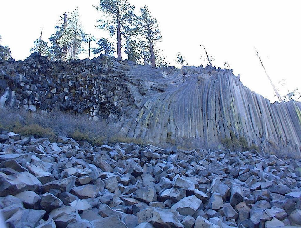
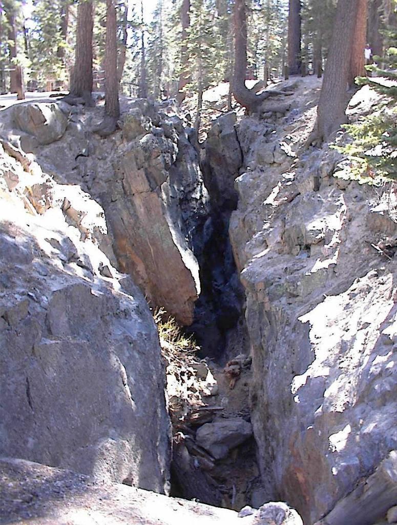
The Post Pile is a nice short hike and I thought it was well worth it. Its not magical but it is an interesting chunk of columnar basalt. You can hike around it and walk on the mix of hexagons and pentagons caused by the cooling lava. It is exposed because a glacier sheared it off. Very nifty geology. The big crack on the northern road out of town is pretty interesting too, caused by a major earthquake in the 1980's. Despite claims to the contrary, Long Valley Caldera is NOT going to explode. The magma source is cut off, and the activity moved north to Lassen etc. All the volcanos are in the Cascades. So yes, Mammoth is safe real estate to buy. It will not explode.
 | |
| So real it looks fake. |
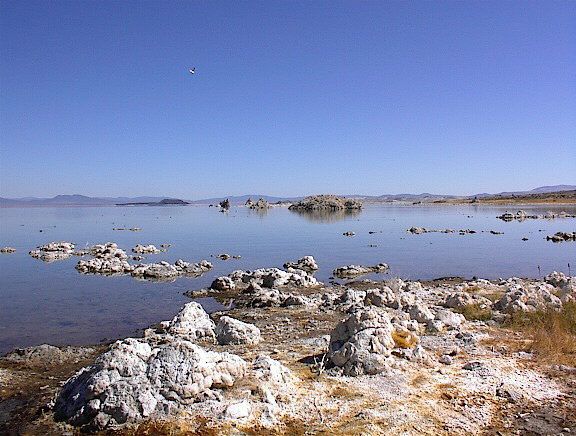
In the winter, 120 is closed, and being a non-cleared road winter lasts around 8-9 months a year. Keep that in mind. Tuolumne Meadows is very pretty, almost pristine example of a high alpine meadow. The grass is frost resistant and makes a nice broom or brush. I had one, made it myself for sweeping out our tent. I don't recommend camping there because the Black Bears are mean and will tear apart your car, which is easy for them. Cars are just aluminum foil as far as a bear is concerned. They're really strong. If you're there for the day, its fun and the far side goes down a beautiful mountain canyon which is terrifyingly steep and eventually lands at Lee Vining on 395 at Mono Lake. You can go North or South from there.
Oh, one other cool place on 395, north of Mono Lake before you reach Bridgeport. That's Bodie State Historical Park. Bodie was a silver mining boom town. The mine ran out of silver after decades of mining so people moved away, but nobody moved in so the houses were abandoned. As it is dry there, they are still, mostly, standing, complete with garbage around them. They were occupied long enough to have gas pumps in 1935 but eventually the last person moved out and the State of California got the place as a park. It is a monument to our boomtown economy, our continuous series of economic bubbles. If you want to see a classic ghost town, this is the place to go. Bring a camera and long sleeves. It is high elevation so walk slowly.
Finally, there is Westgaard Pass, which starts at the Junction next to Big Pine, CA, and leads East to both Deep Springs Valley (cool for geologists thanks to the Poleta folds and the Original Deposition Dolomite in the dry lake visible from them there are only 3 or 4 places on earth which have this) and the top of the White Mountains which contains the oldest known trees on earth, the Bristlecone Pine forest, which is at 11,000 feet. The trees there have evolved to being only partially alive at any one time, the rest of their wood dead and exposed to the elements. The dolomite rock is so poor in nutrients they can barely survive, but the perched aquifer supplies their water and the lower temps means they just trickle along. Its an amazing place, really. While part of the road is gravel, it doesn't matter because its East of the Sierra's Rain Shadow, so pretty dry most of the year. You can go there with any front wheel drive car just fine, though I recommend Fuel Injection because the air is so thin most struggle to run otherwise. Once you park, you need to walk slowly. It is COMMON for people to get out of their cars and actually FAINT from the thin atmosphere. You can DIE from altitude sickness. No really. Die. So be careful, move slowly, and recognize any potential problems before they drop you. I do not recommend long hikes at that altitude, which just gets you further from help when you faint. Take the pictures at the top of the mountain, absorb the experience. Then get down the mountain before you get sick.
These are nifty roads in the Sierras, both West and East sides. There are many more worth visiting, but I will let you explore them yourself. It's a BIG WORLD, and it is up to you what to see of it.
Gorgeous pictures. I must go back to the Sierras
ReplyDeleteI took those with a 1.0 MP camera that weighed over a pound about 13 years ago. It was fun. That's when I met my wife. With a better camera I would like to retake some of those shots. I've managed to do okay with post-processing, but better processing of blues and higher resolution would be helpful for really powerful images. I'm glad you liked my pictures though. Despite having primitive equipment I'm rather proud of them too. A modern 6 MP camera with a good lens and color balance is the equal of most color film cameras.
ReplyDelete